Tournemire experimental station
Located in a former railway tunnel almost 2 km long, dug between 1882 and 1888, this full-scale laboratory aims to acquire methodological and phenomenological knowledge of clayey rocks similar to the Bure site (Meuse/Haute Marne), where Andra could install a radioactive waste repository. This is a fundamental tool for IRSN, enabling it to study the confinement properties of these rocks and the performance of certain components of a repository, with the aim of providing independent expert appraisal for Andra.
Context
A full-scale laboratory at the service of expertise
Acquired in 1992, the Tournemire experimental station, where IRSN has been conducting experiments since 1989, is used for scientific and technical research purposes only. Under no circumstances is it intended to one day house radioactive waste. Furthermore, no radioactive components are introduced for research purposes.
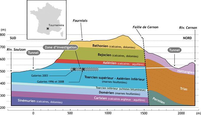
The experimental station is located in the Grands Causses basin, on the southern edge of the Massif Central (south of Aveyron). The century-old tunnel cuts through the Jurassic¹ Toarcian² clay formation. The clay layer, made up of clays and marls, was deposited in the marine environment around 180 million years ago. Located at a depth of between 200 and 250 metres, it is 250 metres thick and is surrounded by limestone formations [geological context] in which aquifers circulate.

In terms of its geological configuration and the nature of the rocks, this experimental site has broad similarities with the one studied by Andra in Meuse/Haute-Marne, but the presence of a hydraulically active regional fault and more local faults constitute extreme conditions (compared with the Andra site, where no such discontinuities have been identified) for assessing the confinement properties of a clay medium on a scale of millions of years.
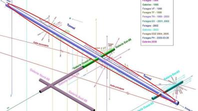
Geological studies have been carried out as part of a number of research programmes since 1990, using various observation and analysis techniques from the surface, the tunnel, the six galleries excavated since 1996 and the numerous boreholes (over 250) drilled in the tunnel and galleries in various directions. Geological knowledge of the area provides the basis for the development of the various research programmes and the choice of experimental areas. It also provides the information needed to test investigation methods and validate models.
The Tournemire experimental station is one of four underground clay research laboratories in Europe, alongside those at Mol (Belgium), Mont-Terri (Switzerland) and Bure (Meuse/Haute-Marne, France). In 2007, it became part of the International Atomic Energy Agency (IAEA) network of centres of excellence3.
1- The Jurassic is a geological period that stretches from around 200 to 145 million years ago.
2- The Toarcian is the last stage of the Lower Jurassic (or Lias) on the geological time scale.
3- This network, called Underground Research Facilities (URF's), brings together around ten partners worldwide.
Photo: Justo Cabrera, IRSN research engineer in geology, at the intersection of a gallery dug into the tunnel.(c) Noak / Le bar Floréal / Médiathèque IRSN
Rifts and fractures
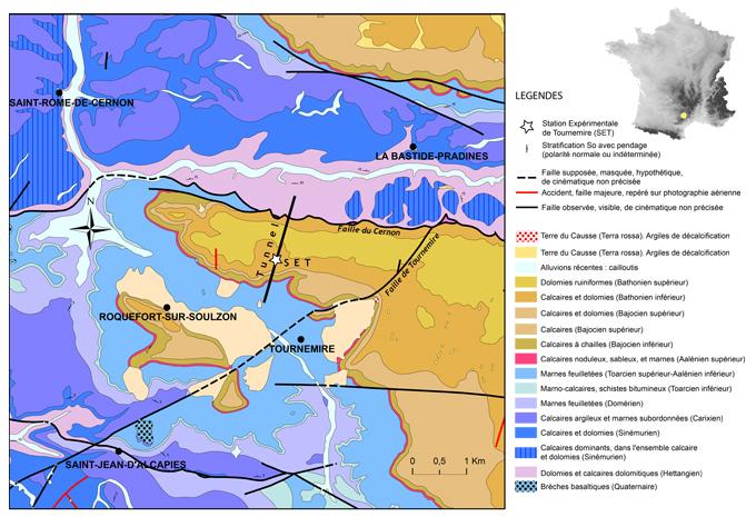
The southern part of the Grands Causses is part of the structural context of the major regional faults which strike close to E-W to E-NE/W-SW. More locally, the Tournemire experimental station is located in a massif composed of Jurassic sedimentary rocks with a simple monoclinal structure, with layers inclined slightly to the north (4-5°) (see geological section opposite). This massif is bounded to the north by the major regional Cernon fault (80 km long), which has played a major role in the tectonic, morphostructural and hydrogeological framework of the region. The local Cirque de Tournemire fault, running NE-SW, is the second kilometre-scale discontinuity (11 km long) close to the Tournemire massif.
The experimental station tunnel crosses the Cernon fault in the northern zone, at MP 1587 [1], where a spring is present. In this zone, the rejection (reverse fault) of this fault [2] is of the order of 400 metres (minimum) and, if we add the rejection as a normal fault produced during Jurassic sedimentation, the total offset is even greater (see geological section). At this point, the fault brings the Upper Toarcian argillites into contact with the dolomitic limestones of the Lias. This fault plays a major role in the circulation of groundwater.
A main fault, secondary faults
On a local scale, the massif is affected by kilometre-scale to metre-scale faults. In the vicinity of the Tournemire experimental station, the largest discontinuity extends over a kilometre in a N-S direction. This fault, known as the main fault (see geological map, in red), was revealed during excavation of the structures at the experimental station and by seismic imaging [3] from the surface. This is a normal fault that was active during Jurassic sedimentation and was re-stripped during Pyrenean compression (40-50 Ma). This multiphase legacy is responsible for the complex structuring of the fault zone: crushed argillite, slip planes, calcite-filled fractures.
Other faults of hectometric extent, quasi-vertical and trending close to N-S, are present at the site. Attributed to the Pyrenees formation, these faults, known as secondary faults (see geological map), are mainly characterised by zones of crushing of the argillite with associated fractures.
In the areas where the experimental station structures crossed these faults (main and secondary), no groundwater flow was observed. Other NW-SE-trending shear faults are associated with the N-S structures, and may intersect them. The decametre- to metre-scale fracturing is mainly calcite-filled, with pyrite crystals in some cases, and is largely organised along a N-S to NW-SE trend.
In certain sectors, this type of discontinuity controls underground circulation, mainly in the relay zones (see fig1) where the presence of geodes is observed (for example in the East-96 gallery). The upper and lower aquifers are located along fracture zones close to N-S affecting the limestone layers.
1. Metric point, distance expressed in metres from a point of origin, in this case the southern entrance to the Tunnel.
2. Fault rejection, the vertical component of the sliding movement of a fault. For more information on the different types of fault: Fault movements.
3. Imagery used underground that uses the echo of sound waves reflected by geological interfaces (different layers, faults).

A century-old tunnel
One of the advantages of the Tournemire experimental station for IRSN's expert assessments lies in the presence of an old tunnel: the Boutinenque railway tunnel (also known as the Tournemire tunnel), which provides access to the Toarcian argillite, a rock with many similarities to the clay formation studied by Andra at the Meuse/Haute-Marne site. At over 125 years old, it provides a long-term assessment of the disturbance to the clay rock caused by a former underground structure.
This tunnel, which slopes upwards from south to north (1.4%), crosses a large part of the Upper Toarcian clay. In its northern part, it crosses the major regional Cernon fault, which drains part of the region's aquifers (upper and lower): this explains the presence of a spring at its intersection with the tunnel. This spring is channelled under the invert along the axis of the tunnel, with a drain (outlet for seepage water) on the south side of the tunnel.
The original structure
The tunnel is one of a series of engineering structures built at the end of the 19th century as part of a railway project to link Tournemire with the village of Le Vigan. The track was never fully completed, but was used until the 1950s by a freight train linking Tournemire to the Plateau du Larzac.
The tunnel was dug mainly by hand between 1882 and 1888, over a length of 1885 metres (PM 0)1. Geometrically, it has a horseshoe-shaped section, 5.6 metres high and 4.7 metres wide at the base. The facing consists of limestone block masonry, jointed with a lime-based binder.
From army to underground laboratory
In the 1970s, the army acquired the track to enable the extension of a military camp on the Larzac plateau. At the same time, the track was completely replaced. In the end, this extension project came to nothing, as it was halted in the early 1980s.
In 1989, IPSN (now IRSN) began operating the tunnel, with the army's permission, as part of its initial research programmes. In 1992, the IPSN officially became the owner of the tunnel to facilitate its research in support of expert assessments. At the same time, the entire tunnel floor was concreted over in 2003 to facilitate access to the experimental station.
The existence of the tunnel greatly facilitates the construction of galleries and boreholes in different directions, and the bringing in of equipment, thus contributing to the implementation of IRSN's research programmes under easy conditions.
Development in several stages
The experimental station has been built up over the years in three main stages:
After an initial period of exploratory drilling and hydrogeological and hydrogeochemical characterisation, two galleries, each 30 metres long, were dug in 1996 on either side of the tunnel, perpendicularly, starting at MP 690 [1]. The aim of these initial works was to extend the experimental areas for characterisation beyond the tunnel, in particular to analyse the behaviour of the clay rock under the effect of the tunnels, thus marking the start of geomechanical studies.
Crossing a fault zone
These galleries were dug to cross two different zones: a fractured zone with faults to the west (named Galerie Ouest-1996) and a zone with few faults to the east (Galerie Est-1996). These two galleries have a horseshoe-shaped section, similar to the tunnel, but smaller in size (3.7 metres high at the vault and 4 metres at the base). They have no lining, with the exception of a concrete invert for the west tunnel (1996), which makes it possible to characterise the rock without the effects of a lining. The support is made up of metal hangers (TH25 type), with a wire mesh vault. The tunnelling method used is a point attack (dry) [2]. The galleries were instrumented with convergence sections [3], temperature and humidity sensors and extensometers.
From a geomechanical point of view, these two tunnels revealed the existence of a damaged zone around the tunnel (a fractured and/or cracked zone known as the EDZ for Excavation Damaged Zone) and enabled us to characterise the behaviour of the rock in response to excavation, faults and fractures of tectonic origin and the evolution of disturbance in the clay rock over time without a lining (in particular the opening of cracks as a function of variations in ambient relative humidity).
In addition, geophysical, hydrogeological and geochemical studies have gradually been carried out from these galleries.

1. Metric point, distance expressed in metres from a point of origin, in this case the southern entrance to the Tunnel.
2. Excavation was carried out with a 50 kW Alpine machine at the head of the tunnel. The excavation work was carried out by Traçages Arédiens (a former COGEMA unit).
3. Parts anchored to the walls of the galleries to detect deformation.
New galleries were excavated perpendicular to the tunnel in 2003 (from MP 565) [1] in order to extend the experimental zones, analyse the instantaneous behaviour of the rock during excavation and monitor its delayed behaviour: a 40-metre-long instrumented main gallery facing east (named Galerie Est-2003) and a 15-metre-long non-instrumented secondary gallery facing west (Galerie Ouest-2003), used as a workshop zone (for cutting, sample conditioning, equipment storage, etc.).

Analysing the interactions between concrete and argillite
These galleries were excavated by point attack with a quasi-circular section 5 metres in diameter [2], in order to analyse a geometry without pedestals [3], unlike the old tunnel and the 1996 galleries. The installation of instrumentation prior to excavation of the east tunnel enabled us to monitor the behaviour of the rock before, during and after excavation.
The lining is made up of metal hangers (type TH25). The walls of the first ten metres of each gallery were concreted in order to analyse over time the loading of the concrete by the rock (pressure chambers) on the one hand, and the interactions of the concrete with the argillite on the other. The inverts of the two galleries are completely concreted in order to analyse the fractured and/or cracked zone (known as the EDZ for Excavation Damaged Zone) following excavation, in the presence of a concrete invert, a more realistic condition (the galleries of the future repository have a concrete invert) but less practical for auscultation of the EDZ.
The East-2003 gallery crosses the so-called secondary fault [4] already intercepted in the West-1996 gallery, enabling further analysis of this type of structure and its role in fluid transfer. The 2003 galleries are one of the supports used to carry out investigations into the characterisation of the EDZ using geophysical (seismic, electrical), hydraulic and geochemical approaches.
1. Point métrique, distance exprimée en mètres par rapport à un point d’origine, ici l’entrée Sud du Tunnel.
2. Les travaux de creusement ont été effectués par la société BEC avec une machine de 110 kW de puissance en tête.
3. Sur la section d’une galerie, les piédroits (ou pieds-droit) sont les deux parties sub-verticales de la paroi, qui commencent à l’intersection avec le radier et se terminent à l’initiation de la voûte.
The development of IRSN's research programmes at the Tournemire experimental station led to the excavation of new galleries in 2008 to study the performance of sealing structures [1], the detection of faults, zones fractured by the excavation of tunnels oriented like the tunnel (and away from its influence), interactions between concrete and argillite, and transfers.
Exploring the impact of faults and improving the geological model
The 2008 galleries include a 100-metre extension of the west tunnel (1996) (total 130 metres) to move away from the influence of the 100-year-old tunnel, and two galleries parallel to the tunnel, excavated from the 110-metre level of this tunnel: a 50-metre-long gallery to the south (Galerie Sud-2008), and a 20-metre-long gallery to the north (Galerie Nord-2008).

The galleries were excavated using spot attack [2]. Their geometry and lining are similar to the galleries excavated in 1996: horseshoe-shaped cross-section (3.7 metres high at the vault, 4 metres wide at the base), lining with metal hangers (TH25 type) and wire netting at the vault. Only the inverts were concreted to facilitate access to the structures, with the exception of the last few dozen metres of the West and North galleries.
The 2008 galleries will enable a more in-depth analysis of the tectonic faults and fracturing. The main fault zone [3] is clearly visible, as are other shear fault zones. The layout of these galleries enables us to better reconstruct the structural context (faults and fractures) of this central zone and provides an interesting configuration for testing geophysical detection methods and for studies into the role of faults in fluid transfer.
Finally, these galleries are used to analyse the evolution of the fractured and/or fissured zone (known as the EDZ for Excavation Damaged Zone) following excavation and excavation, without lining. Finally, they are used for experiments to assess the performance of sealing systems.
1. These structures are installed at the end of the operating period to close the repository and ensure long-term safety.
2. Digging was carried out by EIFFAGE, with an 80 kW machine at the head.
Geological context
The Tournemire experimental station (Aveyron) is located in the western part of the Causse du Larzac plateau, an area characterised by almost horizontal limestone and clay series dating from the Jurassic period (see geological section). The area is affected by the major regional Cernon fault to the north and the local Cirque de Tournemire fault to the south-east (see map).
From the Primary Era to the present day
Since the Primary Era, the geological history of the Tournemire area has seen a succession of mainly continental and lagoonal sedimentation in the Permian (286-248 Ma), a period of erosion at the end of the Permian, and then a major phase of marine sedimentation in the Secondary Era. This began in the Triassic1 and continued in the Lower Jurassic, initially in the marine environment with the deposition of limestone-dolomitic series (Hettangian, Sinemurian and Carixian series), followed by marl and clay-marl sedimentation with the deposition of Domerian and Toarcian formations (the subject of study in the Tournemire experimental station investigation area).
These clay formations of the Lower Jurassic are followed by the deposition of thick limestone series in the Middle Jurassic (Aalenian, Bajocian and Bathonian). In the Upper Jurassic, the facies are regressive and less well developed than the Lias facies. There are Oxfordian marls and limestones, Kimmeridgian carbonates and Portlandian reefs. At the end of the Jurassic, the sea withdrew from the Grands Causses region, which then became continental. The absence of Cretaceous deposits makes it impossible to clearly establish the evolution during this period.
Note 1: During the Triassic period, fluvial deposits, lacustrine facies, evaporites and marine epicontinental series (beginning of the marine transgression).
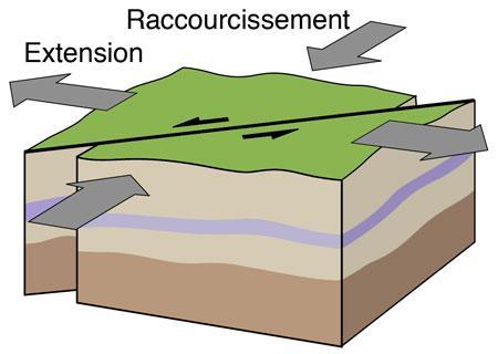
During Jurassic marine sedimentation, extensional tectonics were responsible for the thickening of the series towards the centre of the Grands Causses Basin and the differentiation of the Cévennes threshold. During the Tertiary era, the region evolved into a continental domain. A major tectonic phase, the Pyrenean compression, 40-50 million years ago (Eocene), strongly structured the Grands Causses basin and extended it to the European plate.
The normal Jurassic faults were reactivated with reverse or strike-slip movements, and new faults were also created. Following this tectonic episode, a phase of widespread erosion occurred in the region (Oligocene-Miocene period). From the Miocene onwards, the hydrographic network began to develop, becoming more pronounced in the Plio-Quaternary with the deepening of valleys, the development of karstic networks and the functioning of aquifers.
Nature of the rocks
In the Tournemire area, the Triassic (towards St-Affrique) to Upper Jurassic series are exposed. The limestone and dolomitic Lias (Hettangian-Sinemurian-Carixian) is more than 300 metres thick. The clay formations of the Lower Jurassic are made up of well-compacted clays and marls, over 250 metres thick (Domerian: 50-58 metres; Toarcian: over 200 metres).
The Upper Toarcian is the thickest series (150 metres) and is largely composed of well-bedded claystones, characteristic of clay series. Most of the structures at the Tournemire experimental station (tunnels, galleries and boreholes) are located in this unit. The Lower Toarcian (20 metres thick) is distinguished from the other clay units by its more calcareous and marly-bituminous lithology (lithology rich in kerogen: 10-15% organic matter). The Middle Jurassic, mainly carbonate, largely forms the cliffs and the morpho-structural framework of the Larzac plateau.
It is made up of the limestone and marl series of the Aalenian (25 metres), the massive limestones of the Bajocian (85 metres) and the limestones and dolomites of the Bathonian (over 170 metres). In the Tournemire area, Plio-Quaternary basaltic volcanism, observed regionally on a N-S axis, is present along faults in several places in the form of dykes1 and volcanic apparatuses.
Note 1: A dyke or dike is a vein of magmatic rock that has infiltrated a fissure.